3D Digital Twin
An Aviation Digital Twin Built on
Domestic Terrain and Airport Environments
FLYTO renders real terrain, urban, and airport environments as 3D digital twins, enabling pilots to conduct flight training and operational validation within a visual environment that closely mirrors reality.


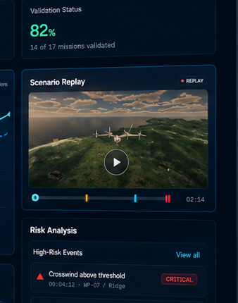
Merging Real Operational Environments with Aviation Data.
Going far beyond simple graphics, we embed domestic terrain, urban areas, airports, flight routes, and planned vertiport sites into simulation space — and integrate them with the flight physics engine.
- Domestic terrain, urban & airport environment rendering
- Route and planned vertiport-based scenario configuration
- Real-time integration with the flight physics engine
3D Digital Twin Application Areas
Expandable across diverse aviation domains — including flight training, airport safety, ATC training, and UAM/eVTOL operational validation.
 Domestic Operational Environment Rendering
Real terrain, urban landscapes, and airport environments are rendered as virtual spaces, providing an environment ideally suited for domestic aviation education and validation.
 Training & Validation Visual Environment
We enable pilots to conduct flight training, procedure training, and operational scenario validation within a visual environment that closely mirrors real-world conditions.
 UAM Operational Validation Expansion
By embedding urban areas, airports, vertiports, and route conditions, we extend our platform into a comprehensive pre-flight validation environment for UAM/eVTOL operations.
A Digital Twin Foundation Specialized for the Domestic Aviation Environment
Through National Geographic Information Institute security review, we hold specialized domestic terrain maps for aviation use — enabling accurate terrain rendering even in environments where map export is restricted. The 3D digital twin is combined with FDAU real flight data, flight physics engine, and aviation operational data integration to complete the spatial foundation of the FLYTO Integrated Simulation Platform.